Yokohama → Rotterdam
vs Suez Canal −4,866 nm · −11 daysDays saved
11 days
42% shorter
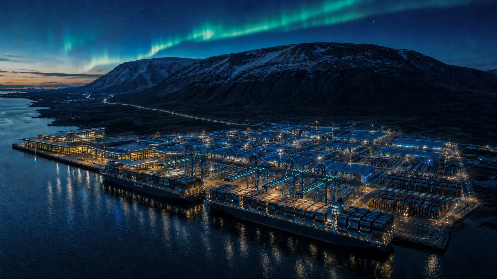
A green industrial park and port on the western shore of Hvalfjörður, beside Grundartangi and within easy reach of Reykjavík. Engineered for the circular economy.
Project overview
When the future Arctic Route opens
The route marked on the globe above - crossing the Arctic Ocean via the North Pole - is the Transpolar Sea Route (TSR). Distances below combine published sea-lane benchmarks for traditional corridors with TSR paths calculated from the waypoints on this map. Days at sea use corridor-typical speeds from peer-reviewed shipping studies: 12.5 kn in the Arctic, 14.5 kn via Suez, 14 kn via Panama.
Arctic corridors typically sail slower than Suez or Panama services - ice, weather, and operational caution limit speed to roughly 12.5 kn, against 14-14.5 kn on southern routes. Even so, the TSR's geometric advantage is large enough to cut transit time by 6-11 days on Asia-Europe lanes. A 2025 TUM/Everllence study found the Northern Sea Route saves ~15% in time over Suez for Rotterdam-Yokohama; the TSR adds a further ~20% reduction over NSR (Brownlee, 2024).
The TSR path on the globe terminates at Galtarhöfn - a deep-water North Atlantic gateway where Arctic-capable vessels can transship cargo to conventional Europe and US services. As the polar crossing opens to seasonal traffic, this fjord port sits at the natural hand-off between the shortest ocean route and the world's major markets.
The section above describes the future Transpolar Sea Route (TSR) over the North Pole. Here the focus is different: the two Arctic corridors ships can already sail today. The Northeast Passage (east) follows Russia's Arctic coast from the Pacific to the Atlantic; the Northwest Passage (west) crosses the Canadian Arctic from the Pacific. On the globe, both exit at Galtarhöfn before services continue to Europe or the US. Distances are conceptual sums from the map waypoints, not navigational charts.
As mining, energy and project cargo grows in the High North, Galtarhöfn is the last deep-water port before ice-class waters. Supply from North America can stage here instead of detouring through continental European hubs. From Britain and mainland Europe, Galtarhöfn is itself an Arctic industrial port at 64°N.
Arctic-capable feeders can discharge at Galtarhöfn and transfer cargo to conventional deep-sea vessels for Europe and North America, without every ship sailing the full Atlantic leg.
1,000 m of quay and 20 m draft accommodate the largest post-Arctic vessels in a sheltered fjord, with infrastructure few North Atlantic ports can match.
Shorter passages cut fuel and emissions per tonne-mile. Shore power at every berth reinforces the low-carbon story for operators on emerging Arctic lanes.
These figures are not the TSR projections above. Distances sum great-circle segments between waypoints on this conceptual map. Actual voyages vary with ice, season, canal fees, and port calls; both passages remain ice-class and weather-dependent.
Galtarhöfn (GH Harbour) is a new deep-water port and industrial zone on the western shore of Hvalfjörður, directly adjacent to the established Grundartangi area. It is designed to absorb the overflow from Grundartangi, which is at capacity, and to serve as the Greater Reykjavík region's next major cargo and cruise terminal.
One of Iceland's deepest and most sheltered fjords, with up to 20 metres of draft at the quay wall. Natural depth, minimal dredging, world-class approach.
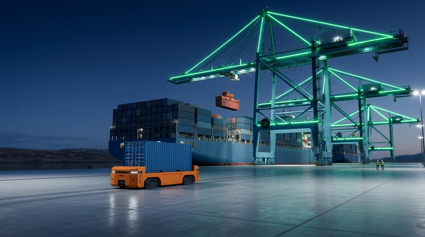
1,000 metres of continuous berth able to serve bulk carriers, container ships, RoRo vessels, and the largest modern cruise ships, all shore-powered.
Of industrial and port land zoned for circular-economy operations, with lot sizes from 0.8 ha to 4 ha and build heights up to 18 m.
Every tenant operates inside a closed loop: clean water, geothermal heat, renewable grid power, and waste-heat recovery from vessels.
Directly west of Iceland's largest industrial cluster, with zero residential neighbours, full existing road network, and immediate grid access.
The Greater Reykjavík region is running out of deep-water port capacity exactly as demand accelerates. Galtarhöfn is the only site within 50 kilometres of the capital that can meet the coming decade of growth.
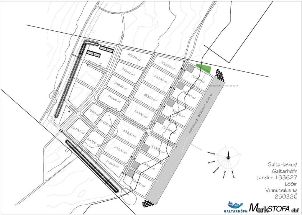
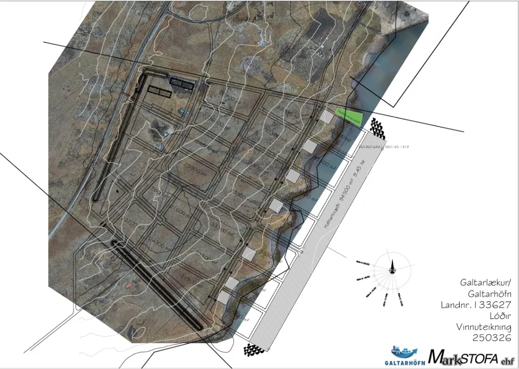
Galtarhöfn sits on the north shore of Hvalfjörður near its western mouth, one of Iceland's most sheltered and deepest fjords, immediately west of the Grundartangi heavy-industry zone on the Klafastaðir lands in Hvalfjarðarsveit. The Hvalfjarðargöng tunnel puts Reykjavík just 40 km away; Akranes is 15 km to the west, Borgarnes 40 km north.
Four major government transport projects will dramatically improve connectivity to Galtarhöfn over the next five to seven years, each one directly strengthens the port's viability.
Sundabraut, Kjalarnes II, Hvalfjárðargöng II and Route 1 upgrades will cut Reykjavík to Galtarhöfn travel to about 25-30 minutes and more than double corridor freight capacity.
Two zones, one vision: an industrial area tuned for large-footprint operations, and a dedicated port area engineered for the largest vessels, all connected to Iceland's renewable grid and to the Gandheimar mine on-site.
101.7 ha split between AF15 industrial (64.6 ha) and a dedicated port zone (37.1 ha), with lots from 0.8-4 ha and quay, power and water engineered for large-footprint tenants.
A multi-purpose terminal designed for bulk, container, RoRo, cruise and project cargo, connected to a 4.8 million m³ verified aggregate reserve on-site at the Gandheimar mine.
Multi-purpose quay for bulk, containers, RoRo, cruise and project cargo, 1,000 m berth, 20 m draft, shore power, tied to the on-site Gandheimar aggregate reserve.
Ferrosilicon, cement, aggregate, fishmeal, grain, fertiliser, direct quay loading from on-site processing.
High-grade material from the Gandheimar mine processed on-site and shipped throughout Iceland and Europe.
Overflow capacity for Sundahöfn as Reykjavík densifies, with faster turnarounds and no queuing.
20 m draft allows the largest modern cruise vessels, 5,000+ passengers, shore-powered while docked.
Vehicles, machinery and heavy equipment, with laydown area and direct ring-road access.
Wind-turbine components, industrial modules, oversized units, 1,000 m quay and 18 m build height.
Every berth is wired for a two-way energy flow: renewable shore power out, residual heat back in. The port behaves like a living organ of Iceland's energy grid.
Every berth exchanges renewable shore power for waste heat: geothermal, grid balancing and autonomous operations designed with Landsnet in mind.
Galtarhöfn is built on the philosophy of the circular economy, the operational model for every tenant on site. Sharing, repairing, reusing, remanufacturing and recycling, with clean water, geothermal heat and renewable electricity as the substrate.
Tenants operate in a closed loop: clean water, geothermal heat, renewable power and on-site materials flow between port, mine and industry, designed so resources stay productive, not waste.
pH 8.8 mineral water, 30-50 L/s
179°C hot water for heat & power
Hydro + geothermal from Landsnet
4.8 M m³ verified aggregate reserve
Processing, prefab, bottling, logistics
Direct mine-to-ship loading, zero intermediate transport
Zoning has been approved by Hvalfjarðarsveit. Public notice of proposal ended on 27 May 2026. Environmental impact assessment is underway under Act 111/2021.
Formal planning case (Skipulagsgáttin), live status and documents →
Zoning approved; public notice of proposal ended 27 May 2026; environmental impact assessment underway under Act 111/2021.
Formal planning track on Skipulagsgáttin with live documents and stakeholder input.
Quay wall, core infrastructure and utilities targeted from 2027 onward.
First deep-water berths and initial tenants scheduled to enter service.
A downloadable reference from the official Galtarhöfn site and independent press coverage.